|
 |
||
|
Monday 12 December Formal opening of the Horsbere Brook flood alleviation scheme. The Environment Agency held a formal opening ceremony of the flood alleviation scheme today, with Richard Benyon MP, Parliamentary Under-Secretary for Natural Environment and Fisheries performing the official opening. Kelly, Jesse and Peter where present from the committee to express thanks on behalf of all the residents to all agencies and persons involved in delivering this flood protection scheme for our homes. Kelly: "On behalf of the committee and all of the residents that were affected in the summer of 2007 I would like to say an enormous thank you to all of the organisations that have come together to see our flood defence system become a reality. I am absolutely thrilled that, depsote the current economic climate, our flood risk status has been lifted and I hope that we will all be able to rest in our beds a little easier on a rainy night." To see more photos of the balancing ponds see the alleviation scheme photo page. 

|
|||
 |
 |
||
|
The flood committee cannot be held responsible for the content of advertised sites.
|
|||
|
|
||
|
Wednesday 7 December The Horsbere Brook flood alleviation scheme is now complete! After a summer of work the Environment Agency have completed the storage ponds for the Horsbere Brook reducing the flood risk to Longlevens, Longford, Elmbridge, Hucclecote and Brockworth. To mark this major achievement residents have been invited to the opening ceremony on Monday the 12th of December at 10:00am (note this is updated from the time listed in the EA news letter). Below is a reproduction of the latest Environment Agency news letter.
|
|||
|
|
||
|
|
||
|
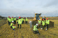
Thursday 24 February The SOD cutting ceremony marks the start of work and was a success. Kelly attended the SOD cutting ceremony yesterday and has reported back the following. I was fortunate enough to be able to take part in the sod cutting ceremony yesterday, the official opening of the permanent flood defence work for the Horsbere brook. Despite the dire economic times we find ourselves in, our flood scheme is going ahead and should be completed by the end of August. The Environment Agency have purchased just over 49 acres of land to carry out the scheme and it will increase our flood risk level to 1:100 year probability which will take our area off the classification as a flood risk category. A fantastic achievement my thanks on behalf of the committee go out to the Environment Agency, county and city council and our local councilors for not giving up on this!
|
|||
|
|
||
|
|
||
|
Friday 18 February The Enivornment Agency have provided a map for the SOD cutting ceremony on the 23rd of February, click here to download it. The Citizen would like to run a positive story on the start of the flood alleviation work and have requested to get a photo with as many residents as possible next to the brook. The planned time for this photo is Sunday the 20th of February at 10:00am and it should only take 5 minutes, please inform your immediate neighbours who may not be aware. |
|||
|
|
||
|
|
Friday 4 February EA invite local residents to the sod cutting ceremony. Note change in date and time! The short ceremony will take place at 3 pm on Wednesday, 23 February, and last for 45 minutes. A location map showing the meeting place for the event and the most convenient car park will be sent to attendees in the near future. Please confirm if you would like to attend by Tuesday, 15 February 2011 to sarah.harcombe@environment-agency.gov.uk or contact Sarah on 07769 886125. |
|
|
|
||
|
|
||
|
Thursday 6 January EA progress on flood defences. The land purchase and planning approvals for the flood alleviation schemes for the Horsbere Brook were obtained before Christmas. The Flood Committee are thrilled with the news, as we feared the worst with the cuts being made due to the financial climate but the funding for the scheme is safe and hopefully we can look forward to better flood protection in the near future. We will keep you informed of progress as soon as we are aware of it. |
|||
|
|